The California Natural Resources Agency (CNRA) is developing the plans for conservation activities as directed by the Governor’s Executive Order N-82-20. This Executive Order proposes to protect 30% of California’s lands and coastal waters by the year 2030.
The 31 undersigned organizations and community groups are part of the Orange County Green Vision Coalition formed and coordinated by FHBP. Together we have established a united voice for parks and conservation in the region.
In 2000, the regional non-profit Friends of Harbors, Beaches and Parks (FHBP) created a countywide Greenprint, called the Green Vision Map, that documented the wish list of conservation opportunities for Orange County and beyond. This map is updated annually and has already served as the baseline inventory for the Regional Advanced Mitigation Program within the Orange County Transportation Authority’s Renewed Measure M Environmental Mitigation Program. Through this and other work, conservation continues—but, the pace is slow. We hope additional investments of funding and partnerships can strengthen the prospects that currently exist and help achieve the 30×30 campaign.
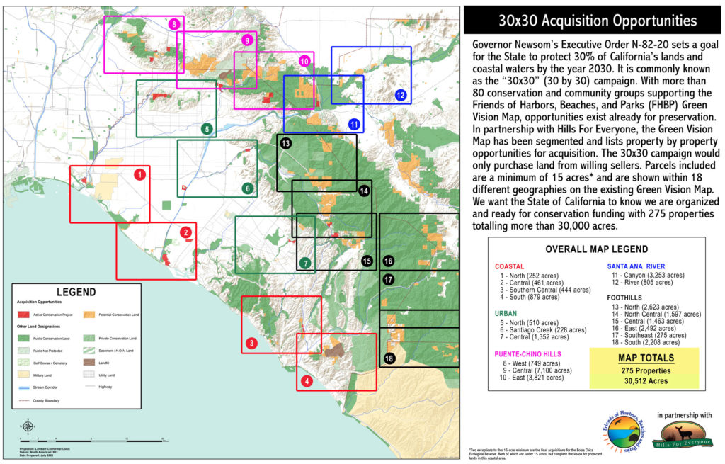
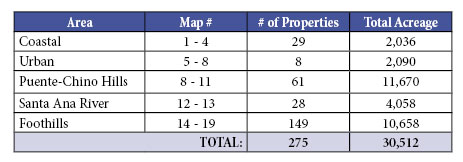
To this end, and in partnership with Hills For Everyone—Founders of Chino Hills State Park—the Green Vision Map was used to document potential acquisition opportunities throughout the region. The map was used to collect information by geography that offers 275 properties totaling over 30,000 acres mainly in Orange County, but also including biologically connected land in Los Angeles, San Bernardino, Riverside, and San Diego Counties. We recognize our habitats and wildlife know no geopolitical boundaries—and we know that adding to the existing reserve system in neighboring counties helps achieve Orange County conservation goals.
The maps below diagram 18 geographies with the potential to help meet the 30×30 campaign goals. Each geography was mapped to include privately owned properties that were 15 acres in size or greater that were not protected, remained in their natural state, did not include habitable structures, and may offer the chance for conservation should the landowner be a willing seller. The geographies are as follows:
View the letter and its 19 attached maps. Go to our 30×30 Documents Page to view each map in large format.